AirSherpa dashboard
Objective: Track AirSherpa usage data for TropoGo core-team for informed business decisions
Company
TropoGo
Category
UI design,
Dashboard design,
Conceptual design
Year
2021
Team size
1 UX designer,
1 Product manager
Role
UX designer
Responsibilities
-
Understand product need & aspirations
-
Understand AirSherpa data parameters & study reference dashboards
-
Advocate best design practices, and conduct team activities
-
Collaborate in a cross-functional team
Understanding AirSherpa
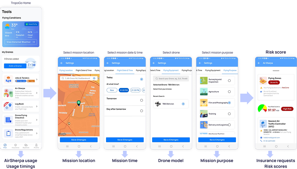
AirSherpa is a feature in TropoGo App, that provides a risk score of a drone mission by assessing variables like geography, drone type, flying time, nature of mission, weather data, drone pilot experience, presence of any critical infrastructure, etc.
User flow for AirSherpa:

Who are we designing the dashboard for?
As on August 2021, AirSherpa onboarded multiple users, drones, and insurance companies and deployed several missions, thus leading to the need for a dashboard view of data at a granular level for the core-team members of TropoGo including the CEO, VPs and Business Development team.
Key metrics as on August 2021
50k+
AirSherpa users
30k+
Drone models
10+
Mission purpose
6
Insurance companies
Unified dashboard for AirSherpa
A scalable dashboard that is accessible, seamless, and easy to consume by the TropoGo team, by which the team can stay updated on the latest developments in AirSherpa usage data.
Dashboard overview

Location-based data

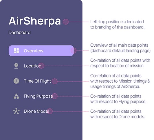
Side navigation panel
With a flat navigation hierarchy, the side navigation panel allow the TropoGo team to monitor data concerning Location, Time of flight, Purpose of flying, and Drone model.


Global control for timeline
Business decisions are based on these key metrics, thus helping the TropoGo team to keep updated with the latest AirSherpa trends without parsing through the granular details.

Global control for timeline
Business decisions are based on these key metrics, thus helping the TropoGo team to keep updated with the latest AirSherpa trends without parsing through the granular details.

Easy visual access of key metrics
Business decisions are based on these key metrics, thus helping the TropoGo team to keep updated with the latest AirSherpa trends without parsing through the granular details.

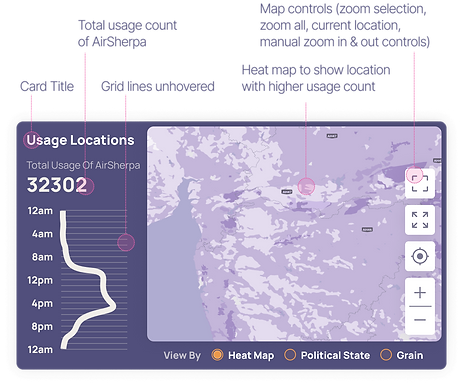
Geographical insights with respect to timeline
Mission locations tell the team where the Drone is flown, whereas Usage locations tell about the pilot's location while checking the drone flying risk score in the AirSherpa.


Enlarged heat map for geographical insights
Affordances to enlarge the heat maps allow the TropoGo team to have a better visual of geographical insights for informed decisions.
.png)
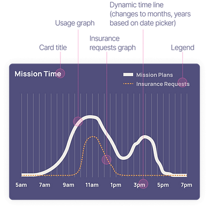
Mission timeline
Mission locations tell the team where the Drone is flown, whereas Usage locations tell about the pilot's location while checking the drone flying risk score in the AirSherpa.


Mission timeline
Mission locations tell the team where the Drone is flown, whereas Usage locations tell about the pilot's location while checking the drone flying risk score in the AirSherpa.


Mission timeline
Mission locations tell the team where the Drone is flown, whereas Usage locations tell about the pilot's location while checking the drone flying risk score in the AirSherpa.


Mission timeline
Mission locations tell the team where the Drone is flown, whereas Usage locations tell about the pilot's location while checking the drone flying risk score in the AirSherpa.


Appendix
UI Design considerations
AirSherpa is a feature in TropoGo App, that provides a risk score of a drone mission by assessing variables like geography, drone type, flying time, nature of mission, weather data, drone pilot experience, presence of any critical infrastructure, etc.
Column grid

UI Design considerations
AirSherpa is a feature in TropoGo App, that provides a risk score of a drone mission by assessing variables like geography, drone type, flying time, nature of mission, weather data, drone pilot experience, presence of any critical infrastructure, etc.
Colour scheme


Ideation

UI Design considerations
AirSherpa is a feature in TropoGo App, that provides a risk score of a drone mission by assessing variables like geography, drone type, flying time, nature of mission, weather data, drone pilot experience, presence of any critical infrastructure, etc.
Typography


Previous design iterations
Samsung’s legacy framework for Galaxy ecosystem provides larger themes that houses all MDE features functioning across multiple galaxy devices.

